🌍 Your knowledge portal
historia

The Oldest Solar Observatory Outside the Maya Area: INAH Confirms 2,500-Year-Old Complex in Tetelihtic

📅 2026-10-25⏱️ 12 min read📝
⚡

Quick Summary

Investigative report on INAH's confirmation of a 2,500-year-old Group E solar observatory in Puebla, the oldest documented outside the Maya world. Mexico's National Institute of Anthropology and History (INAH) has confirmed that the monumental ceremonial center of Tetelihtic, located in the municipality of Teteles de Ávila Castillo within Puebla's Sierra Norte, operated more than 2,500 years ago as a sophisticated pre-Hispanic solar observatory.

Key Takeaways:

  • Archaeological investigations by INAH confirm that the Tetelihtic site in Puebla houses the oldest Group E solar observatory documented outside the Maya area, dating between 1000 and 600 BCE.
  • The architectural complex doubles the spatial footprint of Guatemala's famed Uaxactun observatory, incorporating a 90-meter eastern platform and a western viewpoint facing the mountain horizon.
  • Archaeoastronomical surveys demonstrate the structures precisely recorded solstices, equinoxes, the maize agricultural cycle, and the February 14 rising of Canopus, marking the Mesoamerican civil year.
The Oldest Solar Observatory Outside the Maya Area: INAH Confirms 2,500-Year-Old Complex in Tetelihtic
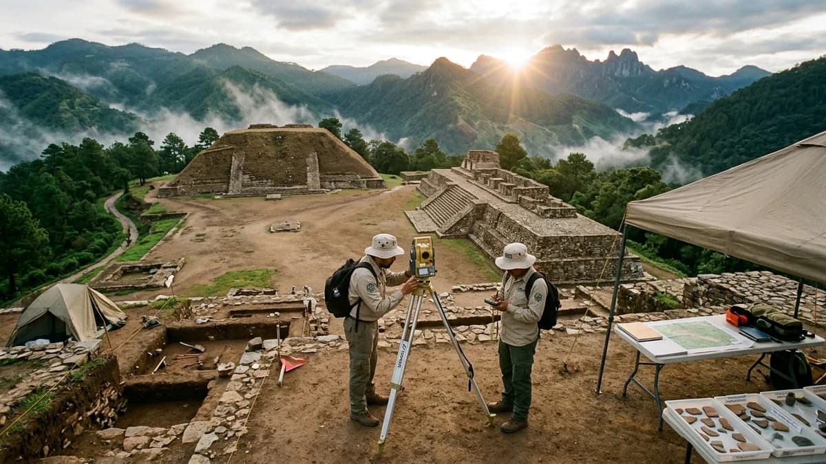
The Oldest Solar Observatory Outside the Maya Area: INAH Confirms 2,500-Year-Old Complex in Tetelihtic — High-Fidelity Artistic Illustration created by artificial intelligence based on scientific research.

The Tetelihtic Solar Observatory in the Sierra Norte of Puebla
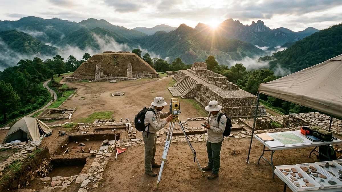
Documentary archaeological recreation based on INAH field research at the Tetelihtic site in Puebla, showing the solar alignment across the monumental plaza at dawn with precision surveying equipment. (Image: Mundo Incrível / High-Fidelity Artistic Illustration)

Mexico's National Institute of Anthropology and History (INAH) has confirmed that the monumental ceremonial center of Tetelihtic, located in the municipality of Teteles de Ávila Castillo within Puebla's Sierra Norte, operated more than 2,500 years ago as a sophisticated pre-Hispanic solar observatory. The extensive field project, directed by archaeologist Alberto Diez-Barroso Repizo under the auspices of the Teteles de Ávila Castillo Archaeological Project, identified the first monumental Group E astronomical complex ever recorded outside the Maya region. The settlement dates to the Middle Preclassic period (between 1000 and 600 BCE) and features dimensions twice the size of the celebrated prototype at Uaxactun, in Guatemala's Petén jungle.

This discovery upends long-standing scholarly paradigms that credited the invention and primary dispersal of monumental solar observatories exclusively to southern Maya lowlands. High-precision geodetic and topographical measurements confirm that Tetelihtic's central plaza was engineered as a scientific instrument of stone and earthen masonry capable of calculating solstices, equinoxes, and orbital trajectories against surrounding mountain peaks. The complex governed the two most sacred milestones of the Mesoamerican agricultural calendar: preparing maize seeds in mid-February and executing the primary autumn harvest in late October.

Beyond tracking the daytime solar cycle, archaeological excavations and archaeoastronomical calculations verified alignments with the star Canopus, the second-brightest star in the nighttime firmament, which heralded the start of the pre-Hispanic civil calendar. The sheer scale of Tetelihtic's platforms reveals prehistoric trade networks linking the Gulf of Mexico, the Central Mexican Highlands, and early Maya territories, offering vital clues into the ancestral lineages that preceded the classic Totonac civilization.


The Breakthrough Rewriting Preclassic Mesoamerican Astronomy #

For more than a century, archaeological textbooks maintained that formal astronomical architecture in Mesoamerica originated within the tropical lowlands of the Maya Petén basin. The canonical Group E layout, named after the original complex excavated at Uaxactun during the 1920s by Oliver Ricketson and Frans Blom, was regarded as an exclusively Maya or late Olmec innovation. Tetelihtic introduces an observatory complex twice the physical scale of the classic Guatemalan model, established deep within Puebla's rugged Sierra Madre Oriental.

The archaeological site, locally known as "Los Cerritos," was historically viewed by nearby communities as a collection of eroded earthen mounds covered by native pine and oak scrub. Systematic topographic mapping, stratigraphic trenching, and high-precision GNSS receiver surveys exposed the calculated symmetry of the ancient urban layout. The central ceremonial plaza was not laid out according to haphazard terrain contours, but rather designed around geometric equations and sightlines engineered to track recurring celestial cycles.

Stratigraphic correlations and Middle Preclassic ceramic typologies confirm that Tetelihtic flourished between 1000 and 600 BCE. Ancient builders transported and compacted hundreds of thousands of tons of earth, river cobbles, and hewn limestone blocks to create monumental terraces. This collaborative effort demonstrates the existence of a stratified, highly organized chiefdom in the highlands of Puebla centuries before the emergence of urban centers like Teotihuacan or Cholula.

This chronological primacy challenges theories regarding the unidirectional diffusion of astronomical knowledge from coastal lowlands to highland plateaus. The society residing at Tetelihtic already possessed sophisticated spatial trigonometry and independent observational science. By turning the rugged silhouette of adjacent mountain ridges into a natural sighting grid, they transformed the physical landscape into an enduring astronomical clock.


The Architectural Puzzle: Deciphering the Group E Astronomical Layout #

In Mesoamerican archaeology, the term Group E identifies a standardized spatial configuration featuring a central quadrangular plaza with two primary structures positioned along an east-west axis. To the west stands an isolated pyramidal platform or mound with a frontal stairway oriented eastward, serving as the stationary observation post. To the east extends an elongated platform supporting three elevated temples or stone markers that delineate the rising Sun across the seasonal cycle.

       [NORTH]
          |
  (Summer Solstice)
          ^
          |      [Elongated Eastern Platform - 90 meters]
          |      +--------------------------------------+
          |      | North Temple                         |
          |      |                                      |
[Viewing Point]  | Central Temple (Equinoxes)           |
(Western Mound)  |                                      |
     [46m] ----> | South Temple                         |
                 +--------------------------------------+
          |      ^
          |      |
  (Winter Solstice)
          |
       [SOUTH]

The functional mechanic of this architectural arrangement is geometrically elegant in its optical design. A priest-astronomer stationed at the center of the western platform directs their line of sight eastward across the open plaza.

On the summer solstice (June 21), the solar disk rises directly over the northeastern corner of the elongated platform. On the winter solstice (December 21), sunrise aligns with the southeastern corner, while spring and autumn equinoxes rise directly over the center of the eastern structure.

Structural Parity with Uaxactun and the Monumental Scale of Puebla #

When archaeologist Alberto Diez-Barroso Repizo digitally overlaid Tetelihtic's site plan onto Uaxactun's surveyed blueprint, angular alignments matched with extraordinary fidelity. The most unexpected revelation, however, lay in the sheer physical scale of the Mexican structures. While Uaxactun's eastern platform measures roughly 45 meters in length, the eastern platform at Tetelihtic extends an impressive 90 meters along its north-south axis.

This doubled footprint required sophisticated geotechnical mastery from the ancient architects of the Sierra Norte. A platform spanning nearly one hundred meters demanded precise levelling across steep, irregular mountain topography vulnerable to tropical downpours. Excavators uncovered subterranean stone drainage conduits and compacted gravel foundation layers engineered to prevent differential settling and preserve sighting accuracy across centuries of use.

The expansive open plaza separating the two platforms accommodated thousands of participants during public rituals coordinated with solar events. The dramatic morning spectacle of golden sunlight illuminating carved plaster facades atop the pyramids served ideological and religious functions alongside scientific observation. Calendar precision reaffirmed the divine authority of ruling elites, legitimizing their role as intermediaries between cosmic forces and societal prosperity.

The Mountain Ridge as a Natural Geodetic Reticle #

Unlike the dense tropical plains of Guatemala's Petén basin, where visual horizons remain low and featureless, the highland landscape of Puebla is punctuated by sharp volcanic peaks. Tetelihtic's master builders transformed this rugged topography into an operational advantage. They positioned the ceremonial core on an elevated natural plateau that incorporated distant mountain summits and notches as integrated sighting markers.

Morning sunlight did not simply clear the constructed stone platforms; it burst forth from specific topographic gaps and prominent peaks along the eastern sierra. This union of sacred landscape (cosmovision) and orthogonal architecture is recognized in archaeoastronomy as an "artificially calibrated horizon." Stone structures functioned as sighting crosshairs on a geodetic transit, tying celestial mechanics directly to geographic terrain.

Recent archaeological investigations at major sites, such as the lost Maya megacity of Valeriana in Mexico, have demonstrated the advanced environmental planning of pre-Columbian societies. Tetelihtic reflects this shared pre-Hispanic brilliance in harmonizing monumental construction with natural surroundings. The remarkable preservation of these alignments testifies to the builders' sophisticated command over environmental physics.


Archaeoastronomy and the Sacred Calendar: From the Solstices to Canopus #

The classic Mesoamerican calendar system relied on the interlocking synchronization of two fundamental cycles: the 365-day solar year (Xiuhpohualli) and the 260-day sacred divinatory count (Tonalpohualli). The intersection of these cycles created the 52-year calendar round, after which dates reset to their shared starting point. Tetelihtic operated as a master calendar clock capable of regulating these cycles and preventing seasonal drift over generations.

In addition to cardinal solar stations (the two solstices and two equinoxes), Teteles de Ávila Castillo marked crucial agricultural milestones essential for community survival. In high-altitude subtropical mountain zones, modest seasonal temperature and precipitation shifts determine the success or failure of maize, bean, and squash harvests. Determining the precise day to sow seed stock was a vital matter of collective security.

+-----------------------------------------------------------------------------+
|               TETELIHTIC ARCHAEOASTRONOMICAL CALENDAR                       |
+-------------------+-----------------------------------+---------------------+
| Solar/Star Date   | Astronomical Milestone            | Agricultural Role   |
+-------------------+-----------------------------------+---------------------+
| February 14       | Heliacal appearance of Canopus    | Slash and sowing    |
| March 21          | Spring Equinox (central alignment)| Initial germination |
| June 21           | Summer Solstice (north corner)    | Field weeding       |
| September 23      | Autumn Equinox (central alignment)| Ear maturation      |
| Late October      | Pre-winter solar alignment        | Harvesting & drying |
| December 21       | Winter Solstice (south corner)    | Storage & rituals   |
+-------------------+-----------------------------------+---------------------+

The February 14 Marker and Agricultural Ground Preparation #

One of the most consequential findings confirmed by INAH researchers is an intentional sightline tracking sunrise around February 14. Within Mesoamerican calendar traditions, mid-February marked the inaugural day of the first civil month (Atlcahualo, or the season of field preparation). This sacred moment signaled farmers to clear hillside plots, burn agricultural residue, and prepare topsoil for ceremonial planting before seasonal rains arrived.

Simultaneously, the brilliant star Canopus (Alpha Carinae), the second-brightest star in the entire night sky, rose above the southern mountain horizon at twilight. Structure 1, the site's primary pyramid, exhibits an azimuthal alignment calibrated specifically to the rise of Canopus over southern ridges during that era. This dual solar and stellar alignment provided priest-astronomers with an infallible cross-referencing system.

Sowing maize into dry soil in mid-February ensured seeds were planted deep enough to withstand late-season highland frosts. If farmers planted prematurely, unseasonable freezes across Puebla's mountains would destroy tender seedlings. Tetelihtic's solar observatory served as a scientific buffer against climate miscalculations, safeguarding the food security of thousands of residents.

The October Horizon Alignment and Autumn Maize Harvesting #

At the opposite end of the seasonal spectrum, Tetelihtic's architectural sightlines precisely bracketed the closing days of October. This period coincides with the end of the rainy season along the eastern flanks of the Sierra Madre Oriental and the onset of dry northern air. Maize ears reached full physiological maturity and required immediate harvesting before excessive moisture triggered kernel rotting on the stalk.

The October solar alignment served as an imperative community signal to mobilize labor for harvesting, transport, and long-term storage in communal granaries. Harvest ceremonies celebrated soil fertility and honored agricultural deities with sacred offerings. Stratigraphic excavations in the central plaza uncovered ceremonial deposits containing polished stone celts, obsidian blades, and ritual ceramic vessels interred during these solar alignments.

Just as discoveries at ancient settlements like Shég′ Xdaltth′í′ in Alaska demonstrate human ingenuity in overcoming extreme environments, Tetelihtic highlights early mastery over mountainous ecosystems. Precision astronomy provided the empirical foundation that made dense, permanent population centers possible in Puebla's cloud-forested heights.


Site Anatomy: Structural Dimensions and Architectural Parameters #

Systematic excavations conducted by the INAH Puebla Center enabled precise metric documentation of the architectural platforms forming Tetelihtic's observatory. Each structure was erected with a core of compacted earthen sediments and sorted river gravel, revetted with dressed limestone masonry bonded with lime-clay mortar. The table below outlines the structural, functional, and chronological parameters documented across the site:

Architectural and Metric Parameters of the Tetelihtic Astronomical Complex #

Structure / Sector Ground Plan Dimensions (m) Estimated Height Azimuthal Orientation Scientific and Ritual Function Confirmed Chronology
Eastern Platform (Elongated Base) 90 m (N-S) × 40 m (E-W) 6 to 8 meters Formal North-South (eastern alignment) Horizon marker for solar solstices and equinoxes Middle Preclassic (1000–600 BCE)
Western Platform (Observatory Station) 46 m (N-S) × 27 m (E-W) 4 to 5 meters East-West frontal Fixed sighting station for priest-astronomers Middle Preclassic (1000–600 BCE)
Structure 1 (Main Pyramid) 52 m per side (quadrangular) 12 meters South-Southeast axis Stellar marker for the February rising of Canopus Middle / Late Preclassic
Structure 2 (Civic Building) 50 m in length × 27 m in width 4 meters East-West Priestly quarters and ceremonial offering storage Middle Preclassic (800–600 BCE)
Central Ceremonial Plaza Approx. 120 m × 90 m Leveled ground surface Geodetic alignment Public assembly courtyard for astronomical rites Middle Preclassic (1000–600 BCE)
Comparative Group E (Uaxactun, Guatemala) 45 m (N-S) × 18 m (E-W) 4 to 6 meters Canonical East-West Prototype solar observatory of the Maya lowlands Late Preclassic (600–300 BCE)

Metric comparisons with Uaxactun highlight the unprecedented scale of the Puebla complex. Tetelihtic's eastern platform spans twice the length of its Guatemalan counterpart, establishing a substantially wider optical baseline. This architectural evidence demonstrates that precision geodetic engineering had attained full maturity in the Mexican highlands during the first millennium BCE.


Trade Corridors and the Genesis of Indigenous Cultures in Puebla #

The presence of a monumental solar observatory in Teteles de Ávila Castillo illuminates an active prehistoric trade corridor connecting the Central Mexican Highlands with the Gulf Coast. Puebla's Sierra Norte forms a natural ecological barrier between dry interior lacustrine basins and humid coastal lowlands. Ancient trade caravans transporting green obsidian, polychrome ceramics, quetzal plumes, salt, and rubber traveled through mountain passes controlled by Tetelihtic.

Ceramic fragments recovered from the deepest strata display clear stylistic affinities with Gulf Coast Olmec traditions, alongside regional styles shared with the Tlaxcala and Tehuacán basins. This convergence indicates that the observatory did not develop in isolation, but functioned as a cosmopolitan hub of cultural, commercial, and religious exchange. Sages and traders converged upon the sacred plaza to synchronize calendars and solidify regional alliances.

INAH archaeologists and anthropologists emphasize that Tetelihtic offers critical evidence regarding the deep roots of the Totonac culture. The Totonac people, who centuries later built the urban center of El Tajín on the Gulf lowlands, preserve oral traditions placing their ancestral origins in Puebla's misty mountains. Tetelihtic's layout embodies core spatial and astronomical principles that endured for millennia within regional indigenous communities.

As excavations continue with modern non-invasive geophysical tools, including ground-penetrating radar and surface magnetometry, additional buried architectural features are coming to light. The solar observatory of Tetelihtic stands as a foundational monument of American archaeology, affirming that mathematical and astronomical genius flourished across diverse landscapes long before the rise of classic empires.


Academic References and Archival Sources #

  • INAH (Instituto Nacional de Antropología e Historia): Archaeological Research Bulletin — Confirman existencia de observatorio solar de más de 2,500 años en Teteles de Ávila Castillo, Puebla. Proyecto Arqueológico Teteles de Ávila Castillo, Centro INAH Puebla.
  • Diez-Barroso Repizo, Alberto: Arqueoastronomía y urbanismo en el Preclásico Medio: El Complejo Astronómico de Tetelihtic en la Sierra Norte de Puebla. Memorias de Arqueología de Puebla, INAH.
  • Aveni, Anthony F.: Skywatchers: A Revised and Updated Version of Skywatchers of Ancient Mexico. University of Texas Press, Austin.
  • Ricketson, Oliver G. & Blom, Frans: Uaxactun, Guatemala: Group E - 1926-1931. Carnegie Institution of Washington, Publication 477.

🏷️ Tags:

📢 Gostou deste artigo?

Compartilhe com seus amigos e nos conte o que você achou nos comentários!

❓Frequently Asked Questions

The Tetelihtic site, located in Teteles de Ávila Castillo in Puebla's Sierra Norte, represents the oldest Group E astronomical observatory ever documented outside the traditional Maya realm. Dating to the Middle Preclassic period between 1000 and 600 BCE, this complex boasts an antiquity exceeding 2,500 years and exhibits monumental dimensions doubling the size of Uaxactun in Guatemala. This discovery demonstrates that highland cultures in the central Mexican plateau possessed advanced astronomical engineering and shared monumental urban design paradigms long before the Classic Maya peak.
Celestial tracking occurred directly from the elevated Western Platform, a 46-meter-wide stone structure serving as a permanent focal observation post for ancient priest-astronomers. From this western vantage point, observers directed their sightlines across the expansive central plaza toward the monumental 90-meter-long Eastern Platform and the surrounding mountain ridges. The rising Sun during the summer and winter solstices aligned exactly with the northern and southern terminal corners of the eastern structure, while equinoxes and sacred agricultural milestones coincided with central architectural markers calibrated to the highland landscape.
Archaeoastronomical measurements conducted by INAH specialists revealed that Structure 1 at Tetelihtic, a monumental pyramid measuring 52 meters on each side and 12 meters in height, features an azimuthal alignment calibrated to the annual emergence of Canopus. As the second-brightest star in the night sky, Canopus achieved its primary visibility in mid-February, a milestone marking the official start of the 260-day Mesoamerican ritual calendar. This stellar alignment signaled the critical moment for field clearance, soil aeration, and ceremonial maize planting ahead of spring rains.

Receba novidades!

Cadastre seu email e receba as melhores curiosidades toda semana.

🔒 Sem spam. Cancele quando quiser.

💬 Comentários (0)

Seja o primeiro a comentar! 👋

📚Related Articles

The 9-Chamber Underground Timber Palace: Archaeologists Unseal the Largest Chu Royal Tomb in 2,200 Yearshistoria

The 9-Chamber Underground Timber Palace: Archaeologists Unseal the Largest Chu Royal Tomb in 2,200 Years

Scientific excavation of the Wuwangdun tomb in Huainan reveals a colossal 9-chamber subterranean wooden palace, an 88 cm bronze ding cauldron, and 2-meter zithers belonging to King Kaolie of Chu.

⏱️12 minLer mais →
The Silver Scroll Beneath the Skeleton's Chin: X-Rays Unroll 1,800-Year-Old Christian Inscription That Rewrites History in Germanyhistoria

The Silver Scroll Beneath the Skeleton's Chin: X-Rays Unroll 1,800-Year-Old Christian Inscription That Rewrites History in Germany

High-resolution Micro-CT scanning at LEIZA digitally unrolls a 3.5 cm silver foil amulet found beneath a Roman skeleton's chin in Frankfurt, revealing 18 lines of 3rd-century Christian Latin that push

⏱️22 minLer mais →
The 'Mother' of the Golden Bracelet Was a Man: Ancient DNA from Pompeii's Plaster Casts Upends 250 Years of Historyhistoria

The 'Mother' of the Golden Bracelet Was a Man: Ancient DNA from Pompeii's Plaster Casts Upends 250 Years of History

Unprecedented genetic sequencing of bone fragments inside 14 historic plaster casts in Pompeii reveals that the iconic 'mother' holding a child on her hip was an unrelated adult man, while the 'two si

⏱️16 minLer mais →
Valeriana: PhD Student Discovers Lost Maya Megacity on Page 16 of Google with 6,674 Structures in Mexicohistoria

Valeriana: PhD Student Discovers Lost Maya Megacity on Page 16 of Google with 6,674 Structures in Mexico

Archaeological LiDAR reanalysis of overlooked forest carbon data reveals Valeriana, a monumental Maya metropolis with pyramids and a ballcourt hidden beneath Campeche's jungle.

⏱️11 minLer mais →
Laser Drones Reveal Two Lost Silk Road Metropolises at 2,200 Meters Altitude in Uzbekistanhistoria

Laser Drones Reveal Two Lost Silk Road Metropolises at 2,200 Meters Altitude in Uzbekistan

First-ever drone LiDAR scanning in Central Asia's Malguzar Mountains uncovers Tugunbulak, a 120-hectare industrial fortress that forged steel for the Silk Road, alongside its sister city Tashbulak.

⏱️13 minLer mais →
Secret Tomb Beneath Petra's Treasury Reveals 12 Skeletons & 'Holy Grail' Chalice Sealed for 2,000 Yearshistoria

Secret Tomb Beneath Petra's Treasury Reveals 12 Skeletons & 'Holy Grail' Chalice Sealed for 2,000 Years

ACOR and St Andrews archaeologists unearth an untouched burial chamber beneath Al-Khazneh in Petra, containing 12 Nabataean skeletons and intact ceremonial pottery.

⏱️16 minLer mais →
Receba novidades no WhatsApp!