🌍 Your knowledge portal
Ciencia e Natureza

200-Meter Greenland Megatsunami Vibrated Earth for 9 Days: Science Study Decodes Global Enigma

📅 2026-10-29⏱️ 9 min read📝
200-Meter Greenland Megatsunami Vibrated Earth for 9 Days: Science Study Decodes Global Enigma
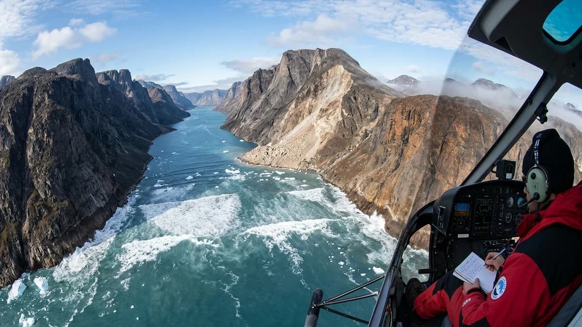
200-Meter Greenland Megatsunami Vibrated Earth for 9 Days: Science Study Decodes Global Enigma — High-Fidelity Artistic Illustration created by artificial intelligence based on scientific research.
⚡

Quick Summary

Catastrophic mountain collapse in Dickson Fjord generated a 200-meter wave trapped in a seiche that shook the entire planet every 92 seconds for over a week. In September, ultra-sensitive seismometers deployed across every continent on Earth, from deep subterranean vaults in Germany's Black Forest to polar recording arrays in Antarctica and northern Alaska, began registering an inexplicable, rhythmic heartbeat.

Key Takeaways:

  • When the initial seismic traces began populating monitors at institutions like the German Research Centre for Geosciences (GFZ Potsdam) and the United States Geological Survey (USGS), geophysicists initially suspected instrument…
  • The breakthrough clue emerged from aerial reconnaissance patrols conducted by the Danish military Joint Arctic Command operating over Northeast Greenland National Park.
  • Upon slamming into the fjord surface, the rock avalanche displaced an extraordinary volume of water.

In September, ultra-sensitive seismometers deployed across every continent on Earth, from deep subterranean vaults in Germany's Black Forest to polar recording arrays in Antarctica and northern Alaska, began registering an inexplicable, rhythmic heartbeat. Unlike conventional tectonic earthquakes, which unleash chaotic bursts of multi-frequency shockwaves that decay within minutes, the incoming signal was a pure, unwavering monochromatic tone with an exact period of 92 seconds. For nine consecutive days, this rhythmic oscillation vibrated the entirety of Earth's crust, perplexing global seismologists who initially designated the phenomenon as a USO (Unidentified Seismic Object). The conclusive resolution to this planetary mystery was published in a landmark study in the journal Science, spearheaded by an international team of 68 scientists from 40 institutions led by the Geological Survey of Denmark and Greenland (GEUS). The source was neither an undiscovered volcanic caldera nor clandestine naval testing, but a colossal 200-meter-high megatsunami generated by the catastrophic collapse of a glaciated mountain peak in remote Dickson Fjord, East Greenland, triggered by accelerated climate-driven glacial thinning.

The raw physical scale of the event defies everyday comprehension: approximately 25 million cubic meters of dense rock and glacial ice plunged from an altitude of 1,200 meters into the icy waters of a narrow, cliff-bound fjord. The immense kinetic impact created a 200-meter water wall that evolved into a rare hydrodynamic phenomenon known as a seiche — a resonant standing wave that sloshed back and forth between the sheer canyon walls every 90 to 92 seconds, acting as a massive hydraulic hammer that pumped mechanical energy into Earth's lithosphere for more than two hundred hours.

The Planetary Seismic Hum That Defied Global Geophysics #

When the initial seismic traces began populating monitors at institutions like the German Research Centre for Geosciences (GFZ Potsdam) and the United States Geological Survey (USGS), geophysicists initially suspected instrument failure or localized sensor artifacts. Planetary seismic networks are routinely calibrated to filter out ambient ocean microseisms, atmospheric shockfronts, or cryospheric ice-cracking. Yet no documented natural event in the history of modern instrumental seismology had ever emitted such an unblemished spectral signature: an unyielding dominant frequency centered at 10.88 millihertz (0.01088 Hz).
The total absence of high-frequency compressional and shear body waves (P and S phases), which universally accompany tectonic fault ruptures, instantly ruled out a standard earthquake. Furthermore, the signal showed virtually no geometric attenuation over the first 48 hours of observation. Seismological stations located thousands of kilometers away in North America, Eurasia, and Australasia recorded the exact same monochromatic rhythm with consistent amplitude, as though an immense planetary tuning fork had been struck in the northern hemisphere.

Scientists cross-referenced real-time acoustic data with the International Monitoring System of the Comprehensive Nuclear-Test-Ban Treaty Organization (CTBTO) and deep-sea hydrophone arrays managed by the Scripps Institution of Oceanography, yet open-basin ocean sensors detected no transoceanic tsunami waves crossing the North Atlantic. The scientific puzzle deepened over the ensuing days as the 92-second period remained rock-solid, pointing directly to a rigid geometric resonance cavity operating on an unprecedented geographic scale.

The Catastrophic Collapse in Dickson Fjord: 25 Million Cubic Meters in Freefall #

The breakthrough clue emerged from aerial reconnaissance patrols conducted by the Danish military Joint Arctic Command operating over Northeast Greenland National Park. Routine observation flights documented catastrophic fresh scars carved along the towering rock flanks of Dickson Fjord, an uninhabited and frozen fjord system situated hundreds of kilometers from any permanent human settlement.

An entire alpine mountain ridge, with a summit cresting at nearly 1,200 meters above the waterline, had suffered catastrophic structural failure. Decades of sustained atmospheric warming across the high Arctic had caused dramatic thinning and accelerated recession of the tributary valley glacier that formerly braced the lower third of the rock face. Deprived of the buttressing cryogenic counterweight of dense ice, the internal joint network within the steeply dipping metamorphic sedimentary strata sheared under shear stress and gravity.

In an event lasting less than two minutes, a geological mass equivalent to ten Great Pyramids of Giza — 25 million cubic meters of fractured bedrock, disaggregated permafrost, and glacial ice — detached simultaneously. The avalanche plummeted through nearly a kilometer of vertical freefall, striking the fjord floor where water depths range from 300 to 500 meters at terminal velocity. The kinetic energy transfer, comparable to the detonation of multi-megaton explosive yields, transformed the catastrophic geological collapse into an instantaneous hydrodynamic shockwave.

The Physics of a Seiche: How a 200-Meter Monster Wave Was Trapped #

Upon slamming into the fjord surface, the rock avalanche displaced an extraordinary volume of water. The initial megatsunami crest surged to a staggering height of 200 meters (650 feet) — more than twice the height of the Statue of Liberty —, stripping tundra vegetation, scouring ancient morainic debris, and exposing naked bedrock up to elevations untouched by seawater throughout the entire Holocene epoch.

In an open marine setting, a wave of this magnitude would dissipate its hydrostatic energy radially, spreading out in expanding concentric ripples and shedding crest height rapidly. However, Dickson Fjord functions as a perfect natural hydrodynamic trap: a tortuous canyon averaging only 2.7 kilometers in width, hemmed in by sheer vertical granite walls that act as acoustic and mechanical reflectors.

Crashing into the opposing cliff face at over 100 kilometers per hour, the massive water wall could not escape toward the open sea due to sharp right-angle bends along the fjord's course. Instead, the wave reflected back across the channel with negligible frictional dissipation, establishing a self-sustaining resonant seiche. For the next nine days, a standing wave crest averaging seven meters in height sloshed back and forth between the opposing canyon walls every 90 to 92 seconds, transferring colossal rhythmic downward pressure pulses into the tectonic plate below.

Anatomy of Geophysical Evidence and the 9-Day Monochromatic Signal #

Proving scientifically that a trapped body of sloshing water in an Arctic fjord could ring the entire planet required an unprecedented convergence of supercomputing hydrodynamic modeling, orbital satellite remote sensing, and global waveform inversion. The 68-member research coalition integrated high-resolution optical and radar data from the European Space Agency's Sentinel-1 and Sentinel-2 satellites, airborne LiDAR terrain mapping, and global seismic arrays.

The following technical table synthesizes the empirical measurements, physical parameters, and comparative benchmarks established during the Dickson Fjord megatsunami investigation:

Geophysical / Metric Parameter Measured Value in Dickson Fjord Typical Tectonic Earthquake Baseline Scientific Significance & Impact
Displaced Rock & Ice Volume ~25 million cubic meters Variable (planar fault dislocation) Largest single slope failure recorded instrumentally in modern Arctic
Initial Tsunami Peak Height ~200 meters at impact zone 1 to 15 meters for deep-sea tsunamis Complete vegetation and soil striping up to 200m vertical elevation
Dominant Seismic Frequency 10.88 mHz (~92-second period) Broadband chaotic noise (0.1 to 10 Hz) Pure monochromatic signal caused by closed-basin fluid resonance
Resonant Seiche Duration 9 consecutive days (~216 hours) Minutes to hours (rapid decay) Extremely low viscous dissipation within steep-walled fjord geometry
Confined Seiche Basin Basin 16 km length by 2.7 km width Unbounded open-ocean propagation Kinetic energy entirely trapped without rapid North Atlantic discharge
Global Seismic Wave Reach Recorded on all continents (Antarctica to EU) Governed by moment magnitude (Mw) First empirical demonstration of a hydrodynamic seiche exciting global lithosphere

Fluid mechanics simulations proved that energy dissipation occurred at an extraordinarily sluggish rate. Each back-and-forth oscillation of the seiche generated a vertical and lateral force exceeding hundreds of billions of Newtons against the canyon basin, radiating long-period Rayleigh and Love surface waves across Earth's mantle that bypassed the high-frequency attenuation typical of regional tectonic tremors.

Global Forensic Investigation: From Satellite Clues to Unmasking the USO #

The scientific investigation mirrored a complex planetary detective inquiry. Within 24 hours of the initial seismic onset, geophysicists in Denmark, Germany, and the United States traced the theoretical arrival angles of the long-period surface waves to Northeast Greenland. Yet existing geological fault catalogs listed zero active tectonic faultlines in that sector of the craton capable of sustaining repetitive tremors.

The breakthrough materialized when researchers at GEUS compared pre- and post-event multispectral imagery from the Sentinel-2 satellite. The imagery exposed an astonishing landscape transformation: an entire 1,200-meter mountain peak had completely vanished, replaced by an enormous, raw escarpment of dark metamorphic rock. Down inside the fjord, the terminus of a nearby tidewater glacier exhibited clean mechanical shear fractures inflicted by the passage of the initial megatsunami wave.

Simultaneously, interferometric synthetic aperture radar (InSAR) measurements acquired by Sentinel-1 mapped the structural deformation of the fjord walls with millimeter precision. Approximately 70 kilometers downstream from the impact site, an unoccupied scientific research station on Ella Island was discovered completely obliterated by the tsunami surge, with concrete foundation pads cracked and heavy expedition equipment swept into the fjord depths.

When supercomputers at GFZ Potsdam and UC San Diego ingested the precise three-dimensional bathymetry of Dickson Fjord and simulated the Navier-Stokes hydrodynamic equations, the calculated sloshing resonance curve matched the recorded 10.88 mHz seismic waveforms down to the second. The nine-day mystery of the planetary "ghost signal" was conclusively resolved.

The New Paradigm of Glacial Geohazards and Emerging Arctic Risks #

The deciphering of the Dickson Fjord megatsunami extends far beyond academic seismology; it delivers an urgent wake-up call regarding the escalating hazards of human-induced climate disruption in high-latitude environments. The Arctic is warming nearly four times faster than the global terrestrial average, a well-documented phenomenon known as Arctic amplification. Accelerated melting does not merely elevate global sea levels through meltwater runoff; it actively destroys the cryospheric cement that has stabilized mountain slopes for millennia.

High-altitude mountain permafrost, which binds deep rock joints in granitic and metamorphic massifs, is thawing at unprecedented depths. Concurrently, the vertical thinning of glacial tongues removes the critical physical buttresses that counteract downslope gravitational drive. The Dickson Fjord catastrophe demonstrates that entire mountain ridges in glaciated environments can fail abruptly without the slow, discernible creep warnings historically documented in temperate alpine regions.

As Arctic maritime corridors clear of pack ice and polar expedition cruise ships carrying thousands of eco-tourists venture into remote fjords across Greenland, Svalbard, and Alaska, the prospect of a passenger vessel encountering an unexpected 50-to-200-meter megatsunami represents an acute operational risk. The findings published in Science underscore the imperative to integrate global seismic monitoring, satellite radar interferometry, and real-time hydrodynamic modeling into automated early warning systems for glaciated fjord landscapes worldwide.

🏷️ Tags:

📢 Gostou deste artigo?

Compartilhe com seus amigos e nos conte o que você achou nos comentários!

❓Frequently Asked Questions

A conventional tsunami is produced by large-scale seafloor dislocation along subduction zone thrust faults, moving an immense volume of water with long wavelengths that manifest as low-amplitude swells in deep open water (rarely exceeding one to two meters) before shoaling and amplifying upon reaching shallow coastlines. Conversely, a megatsunami is triggered by the sudden, concentrated impact of an enormous external mass — such as a subaerial mountain collapse, massive ice calving, or meteorite impact — plunging directly into a confined body of water. The extreme kinetic energy transfer throws a colossal pillar of water upwards at the point of origin, generating localized waves tens or hundreds of meters tall that crash into nearby shorelines with devastating, catastrophic violence.
Fortunately, no human lives were lost during the Dickson Fjord event due to the exceptionally remote and uninhabited wilderness of Northeast Greenland National Park, the largest terrestrial nature reserve on Earth, where no permanent settlements exist within hundreds of kilometers. However, the megatsunami obliterated invaluable archaeological and historic Inuit cultural sites along the fjord banks and pulverized an unoccupied scientific research station on Ella Island, located 70 kilometers from the slide origin. Had an expedition cruise ship or scientific survey vessel been transiting through the narrow fjord channel at that fateful moment, the consequences would have been catastrophic with zero chance of vessel survival.
Yes, scientific consensus confirms that accelerating Arctic warming is directly destabilizing steep glaciated landscapes across polar regions. Rapid retreat and thinning of glaciers deprive steep rock walls of mechanical support, while the deep thawing of alpine permafrost removes the frozen ice cement that binds fractured rock masses together. Meltwater infiltration into newly opened fractures increases internal pore-water pressure, reducing frictional resistance along potential slide planes. With the Arctic heating at four times the global rate, geoscientists warn that catastrophic mountain failures and trapped fjord megatsunamis across Greenland, Alaska, Arctic Canada, and Norway will become increasingly frequent in the decades ahead.

Receba novidades!

Cadastre seu email e receba as melhores curiosidades toda semana.

🔒 Sem spam. Cancele quando quiser.

💬 Comentários (0)

Seja o primeiro a comentar! 👋

📚Related Articles

James Webb Telescope Detects Merger of Supermassive Black Holes at Cosmic DawnCiencia e Natureza

James Webb Telescope Detects Merger of Supermassive Black Holes at Cosmic Dawn

Astronomers confirm the most distant collision between supermassive black holes in galaxy ZS7, unraveling the rapid growth of cosmic titans in the young universe.

⏱️6 minLer mais →
CERN NA62 Experiment Observes Ultra-Rare Kaon Decay and Opens New Window in PhysicsCiencia e Natureza

CERN NA62 Experiment Observes Ultra-Rare Kaon Decay and Opens New Window in Physics

Physicists at CERN achieve five-sigma statistical significance in measuring the rarest decay of the Standard Model, opening doors to physics beyond the known.

⏱️5 minLer mais →
James Webb Telescope Reveals Sand Clouds and Water Vapor on Exoplanet WASP-107bCiencia e Natureza

James Webb Telescope Reveals Sand Clouds and Water Vapor on Exoplanet WASP-107b

Spectroscopic observations from JWST unveil the atmospheric composition of WASP-107b, revealing silicate rain and sulfur dioxide on a low-density world.

⏱️5 minLer mais →
Astronomers Confirm Earth-Sized Exoplanet in Habitable Zone of Nearby StarCiencia e Natureza

Astronomers Confirm Earth-Sized Exoplanet in Habitable Zone of Nearby Star

International teams confirm the characteristics of Gliese 12 b, a temperate exoplanet 40 light-years away with potential for liquid water and atmosphere.

⏱️6 minLer mais →
Preparations for the 2026 Total Solar Eclipse in EuropeCiencia e Natureza

Preparations for the 2026 Total Solar Eclipse in Europe

Scientists and astronomers worldwide mobilize infrastructure in Greenland and Spain for the major total solar eclipse on August 12, 2026.

⏱️6 minLer mais →
The Oldest Solar Observatory Outside the Maya Area: INAH Confirms 2,500-Year-Old Complex in Tetelihtichistoria

The Oldest Solar Observatory Outside the Maya Area: INAH Confirms 2,500-Year-Old Complex in Tetelihtic

Investigative report on INAH's confirmation of a 2,500-year-old Group E solar observatory in Puebla, the oldest documented outside the Maya world.

⏱️12 minLer mais →
Receba novidades no WhatsApp!