🌍 Your knowledge portal
Science & Nature

Wildfire in Spain Forces Evacuation of NASA Deep Space Station

📅 2026-08-04🔄 Updated: 2026-10-12⏱️ 6 min read📝
Wildfire in Spain Forces Evacuation of NASA Deep Space Station
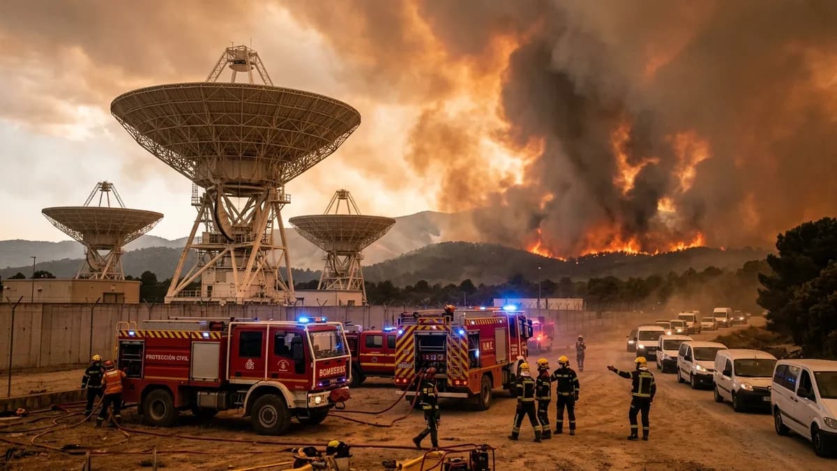
Wildfire in Spain Forces Evacuation of NASA Deep Space Station — High-Fidelity Artistic Illustration created by artificial intelligence based on scientific research.
⚡

Quick Summary

A severe wildfire in Robledo de Chavela forces the emergency shutdown and evacuation of NASA's Madrid Deep Space Communications Complex. A fast-moving forest wildfire driven by extreme Mediterranean summer temperatures and severe drought forced the emergency shutdown and total evacuation of the Madrid Deep Space Communications Complex (MDSCC) in Robledo de Chavela, Spain.

Key Takeaways:

  • Managed by the Jet Propulsion Laboratory for NASA's Space Communications and Navigation (SCaN) program, the Deep Space Network has served as the vital information lifeline for all planetary and deep-space missions since 1963.
  • The blaze erupted during an extreme heatwave where ambient temperatures across central Spain soared past forty-two degrees Celsius, accompanied by relative humidity levels plunging below twelve percent.
  • The comparative table below outlines the operational specifications, geographic coordinates, antenna assets, and flagship spacecraft monitored by the three global hubs of the Deep Space Network:

A fast-moving forest wildfire driven by extreme Mediterranean summer temperatures and severe drought forced the emergency shutdown and total evacuation of the Madrid Deep Space Communications Complex (MDSCC) in Robledo de Chavela, Spain. Situated approximately fifty kilometers west of Madrid, the strategic installation constitutes one of only three specialized ground tracking stations that form NASA's Deep Space Network (DSN). As walls of smoke and advancing flames breached outer perimeter hillsides, base administrators and local civil defense authorities ordered all non-essential personnel to evacuate, placing delicate multi-million-dollar parabolic antennae into automated survival mode.

The emergency highlighted an acute vulnerability at the intersection of terrestrial climate disruption and deep-space exploration. While humanity's robotic emissaries travel through the vacuum of interplanetary space billions of kilometers away, their electronic connection to Earth depends upon physical ground stations anchored in terrestrial ecosystems increasingly exposed to catastrophic wildfires, flash flooding, and extreme weather events. For several hours, the evacuation raised urgent operational questions about whether ongoing missions across the solar system would suffer communication blackouts.

Coordinated emergency responses between Spanish military emergency units (UME), regional forest firefighters, and flight controllers at NASA's Jet Propulsion Laboratory (JPL) in Pasadena, California, prevented physical structural damage to the dishes. Automated handover protocols ensured that spacecraft telemetry and commands were seamlessly redirected across the globe, demonstrating the resilient architectural design of international deep-space networks.

The Tri-Station Architecture of the Deep Space Network #

Managed by the Jet Propulsion Laboratory for NASA's Space Communications and Navigation (SCaN) program, the Deep Space Network has served as the vital information lifeline for all planetary and deep-space missions since 1963. The network's foundational design relies on geographic triangulation: three tracking complexes positioned approximately 120 degrees of longitude apart from one another around the globe. The three primary hubs are situated at Goldstone in the Mojave Desert of Southern California, outside Madrid at Robledo de Chavela in Spain, and near Canberra in the Tidbinbilla Valley of Australia.

This strategic global distribution ensures that as the Earth rotates on its axis, a spacecraft navigating interplanetary space remains continuously in the line of sight of at least one tracking station. Before a spacecraft dips below the local horizon at one facility, a sister station thousands of kilometers away acquires its radio carrier signal, providing uninterrupted twenty-four-hour tracking, command transmission, and scientific data acquisition.

The Madrid complex houses six active high-gain parabolic antennas, anchored by the massive Deep Space Station 63 (DSS-63), a monumental dish measuring seventy meters in diameter and weighing nearly eight thousand tons. Equipped with cryogenic ruby maser low-noise amplifiers cooled to near absolute zero, the antenna possesses the sensitivity required to decode whisper-faint radio signals measuring fractions of a billionth of a watt transmitted from Voyager 1 and Voyager 2 traveling beyond the heliosphere.

Wildfire Outbreak and Emergency Protective Shutdown #

The blaze erupted during an extreme heatwave where ambient temperatures across central Spain soared past forty-two degrees Celsius, accompanied by relative humidity levels plunging below twelve percent. Sparked by dry lightning strikes across pine and scrub-covered hillsides, the fire advanced rapidly toward the valley housing the satellite complex. Spanish authorities deployed ten aerial water-bombing airplanes, four heavy helicopters, and over two hundred specialized military firefighters to establish defensive firebreaks around the high-security installation.

At the complex, site directors initiated the primary emergency containment protocol. Technicians systematically powered down high-voltage microwave transmitters, sealed subterranean waveguide tunnels against caustic smoke and particulate penetration, and engaged automated fire-suppression systems along perimeter fences. Most importantly, engineers commanded the towering dishes to slew upward into the "stow-at-zenith" configuration—pointing directly ninety degrees toward the sky.

Parking the parabolic dishes in the zenith orientation minimizes the horizontal reflective surface exposed to rising heat columns, radiant embers, and turbulent ground drafts. Furthermore, it protects delicate subreflectors and optical alignment mirrors suspended above the dish centers from falling debris or ash accumulation. As the final technical teams evacuated, site monitoring transitioned to automated internal sensors feeding real-time thermal diagnostics directly to JPL flight controllers in California.

Comparative Overview of NASA's Deep Space Network Ground Complexes #

The comparative table below outlines the operational specifications, geographic coordinates, antenna assets, and flagship spacecraft monitored by the three global hubs of the Deep Space Network:

DSN Ground Station Complex Geographic Location Latitude / Longitude Primary Antenna Diameter Key Interplanetary Missions Tracked
Madrid Complex (MDSCC) Robledo de Chavela, Spain 40°25'N, 04°14'W 70 meters (DSS-63) James Webb, Perseverance, Voyager 1 & 2
Goldstone Complex (GDSCC) Mojave Desert, California, USA 35°25'N, 116°53'W 70 meters (DSS-14) Mars Reconnaissance Orbiter, Europa Clipper
Canberra Complex (CDSCC) Tidbinbilla Valley, Australia 35°24'S, 148°58'E 70 meters (DSS-43) Artemis lunar relay, New Horizons, Parker Probe
Estrack Support Network (ESA) Cebreros, Spain / Malargüe, Arg Diverse regional sites 35 meters (standard) BepiColombo, Juice (Jupiter Icy Moons)

Data organized in the comparative matrix demonstrates the absolute parity and inter-station redundancy required to maintain continuous telemetry links with exploratory hardware scattered across deep space.

Follow-the-Sun Reallocation: Automated Orbital Handover #

As Madrid's dishes powered down, JPL network operations controllers enacted emergency "Follow-the-Sun" handover algorithms. Antenna tracking schedules are normally negotiated months in advance between international science teams competing for scarce tracking time. Under emergency contingencies, autonomous scheduling software redistributed critical communication links across available dishes at the Goldstone and Canberra complexes.

High-priority missions operating in dynamic flight phases—such as the Europa Clipper transit, the James Webb Space Telescope's station-keeping orbit at the second Lagrange point ($L_2$), and the Perseverance rover drilling operations in Mars's Jezero Crater—experienced zero data loss. Telemetry streams were rerouted via transoceanic fiber-optic networks directly to secondary ground terminals, while routine background calibration activities for lower-priority satellites were temporarily deferred.

European Space Agency (ESA) tracking stations, including the 35-meter deep-space antenna at Cebreros just thirty kilometers west of Robledo, coordinated with NASA to provide emergency backup capacity. The mutual interoperability between NASA and ESA ground networks proved invaluable, demonstrating that international collaboration provides an essential safety net during localized environmental catastrophes.

Climate Change and the Future of Space Tracking Infrastructure #

The incident at Robledo de Chavela underscores a sobering reality: humanity's reach into deep space remains physically tethered to an increasingly volatile terrestrial environment. Over the past decade, all three Deep Space Network complexes have faced severe climate-related threats. Goldstone has confronted intensifying desert windstorms, flash flooding, and record-breaking heat waves that stress antenna mechanical bearings. Canberra narrowly escaped devastating bushfires during Australia's catastrophic 2019–2020 "Black Summer."

In response, NASA and international space agencies are actively investing in next-generation climate resilience programs. Upgrades include expanding deforested buffer zones around antenna arrays, burying all high-voltage transmission lines underground, and installing automated optical-infrared fire detection networks that identify thermal hot spots miles before blazes reach security perimeters.

Furthermore, aerospace engineers are advancing Deep Space Optical Communications (DSOC)—laser-based communication systems that utilize near-infrared photons rather than conventional radio waves. While optical communication offers data transmission rates up to one hundred times higher than traditional radio frequency systems, laser beams are highly sensitive to cloud cover, smoke plumes, and atmospheric aerosols. The vulnerability of both radio and laser ground stations to smoke and wildfires reinforces the vital need for geographically diverse ground networks and orbital relay architectures.

Thanks to the courageous efforts of Spanish emergency services, the wildfire perimeter was successfully contained without damaging the iconic dishes of Robledo de Chavela. Within thirty-six hours of the evacuation, air quality stabilized, cooling systems were inspected, and technicians brought DSS-63 and its companion antennas back online. The station resumed its silent, watchful vigil, gathering the faint electronic echoes of humanity's furthest voyagers across the cosmos.


References and Authoritative Sources #

🏷️ Tags:

#nasadeepspacenetwork#robledodechavela#madriddsnevacuation#wildfirespain2026#spacecommunication#artemisrelay

📢 Gostou deste artigo?

Compartilhe com seus amigos e nos conte o que você achou nos comentários!

Receba novidades!

Cadastre seu email e receba as melhores curiosidades toda semana.

🔒 Sem spam. Cancele quando quiser.

💬 Comentários (0)

Seja o primeiro a comentar! 👋

📚Related Articles

James Webb Discovers Smallest Brown Dwarfs in IC 348Science & Nature

James Webb Discovers Smallest Brown Dwarfs in IC 348

NASA's James Webb Space Telescope identifies free-floating cosmic bodies barely two times the mass of Jupiter within the young IC 348 star cluster in Perseus.

⏱️6 minLer mais →
Webb and Hubble Discover 27 Frozen Objects in Outer SpaceScience & Nature

Webb and Hubble Discover 27 Frozen Objects in Outer Space

NASA's James Webb and Hubble space telescopes combine infrared and optical data to discover 27 pristine trans-Neptunian objects in the Kuiper Belt using shift-and-stack.

⏱️6 minLer mais →
Hubble Reveals Unprecedented Views of Supernova Cassiopeia AScience & Nature

Hubble Reveals Unprecedented Views of Supernova Cassiopeia A

NASA and ESA release unprecedented Hubble Space Telescope mosaics of supernova remnant Cassiopeia A, mapping 3D blast dynamics and cosmic dust formation.

⏱️6 minLer mais →
Nancy Grace Roman Space Telescope Completes Solar Array TestScience & Nature

Nancy Grace Roman Space Telescope Completes Solar Array Test

NASA's Nancy Grace Roman Space Telescope passes critical solar array deployment and thermal-vacuum tests at Goddard Space Flight Center ahead of its 2027 launch.

⏱️6 minLer mais →
ESA Hera Mission Reveals Colossal Asteroid Shaped DeimosScience & Nature

ESA Hera Mission Reveals Colossal Asteroid Shaped Deimos

Orbital telemetry from the ESA Hera probe reveals that a colossal prehistoric asteroid collision blanketed the Martian moon Deimos in a smooth global regolith mantle.

⏱️7 minLer mais →
Liquid Diamond Oceans Confirmed on Neptune and UranusScience & Nature

Liquid Diamond Oceans Confirmed on Neptune and Uranus

High-energy laser experiments recreate megabar pressures to prove liquid carbon oceans and solid diamond icebergs deep inside ice giants Neptune and Uranus.

⏱️6 minLer mais →
Receba novidades no WhatsApp!