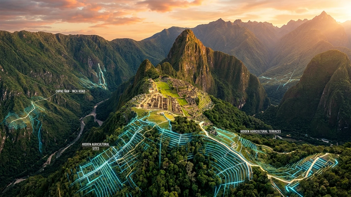
An international team of archaeologists and geodetic engineers collaborating with Peru's Ministry of Culture announced one of the most consequential discoveries in modern Inca archaeology: the identification of an extensive network of secret roads, hydraulic canals, and agricultural terraces hidden beneath the subtropical cloud forest in Machu Picchu National Archaeological Park. Deploying advanced drone-mounted LiDAR (Light Detection and Ranging) sensors, researchers fired hundreds of thousands of laser pulses per second through the dense Andean tree canopy. The resulting high-resolution 3D terrain model revealed over 2.5 kilometers of previously unmapped stone-paved pathways on the right bank of the Urubamba canyon, near the enigmatic Mandor Wall sector.
For more than a century following Hiram Bingham's 1911 introduction of Machu Picchu to the global public, the citadel was primarily interpreted as an isolated, exclusive royal sanctuary perched atop a rugged mountain ridge. However, the groundbreaking topographic telemetry released in August 2026 demonstrates that the monument formed the core of a much broader, hyper-connected regional urban network. The newly charted routes navigate near-vertical precipices with megalithic retaining walls, rock-hewn staircases, and subterranean culverts engineered to withstand torrential Amazonian rainfall.
This monumental infrastructure reshapes historical models of Inca state logistics and territorial control (Tahuantinsuyo) during Emperor Pachacútec's 15th-century reign. Rather than relying solely on the classic Inca Trail, imperial administrators maintained covert access ways and auxiliary supply arteries connecting lowland coca and maize plantations to high-altitude ceremonial temples. Airborne laser scanning overcomes the physical constraints of traditional pedestrian surveys, virtually peeling away dense forest cover without disturbing the delicate Andean cloud forest ecosystem.
Archaeological Comparison: Citadel Core versus Newly Discovered Mandor Complex
Airborne laser scanning has permanently elevated the precision of non-destructive survey methodologies across the Peruvian Andes. To appreciate the scale of the August 2026 discovery, we must compare the architectural features of the well-documented central citadel against the newly revealed Mandor forest complex. These structural findings prove that Machu Picchu's functional and agricultural footprint was at least forty percent larger than historical surveys documented.
| Structural Feature | Traditional Central Citadel | Newly Mapped Mandor Sector (LiDAR 2026) |
|---|---|---|
| Linear Pathway Length | ~1.8 km mapped internal pathways | +2.5 km stone-paved highways with retaining walls |
| Hydraulic Engineering | 16 liturgical fountains and surface channels | Subterranean stone aqueducts tied to river drainages |
| Agricultural Terraces (Andenes) | Prominent East and West agricultural sectors | At least 12 hidden terrace tiers beneath tree canopy |
| Primary Functional Role | Royal, astronomical, and ritual palace | Strategic logistics, supply buffering, and checkpoint access |
Ground-truthing expeditions conducted by Peruvian and European field teams verified the laser anomalies, recovering imperial Cusco Polychrome ceramic sherds and polished masonry tools preserved along the jungle pathways. The retaining walls anchoring the steep ravines utilize mortarless interlocking stonework, proving that Inca master builders mastered slope stabilization in terrain subject to chronic seismic activity and landslides. This tiered drainage matrix prevented tropical downpours from stripping topsoil from the agricultural terraces.
Furthermore, LiDAR elevation models identified small stone observation platforms aligned with mathematical precision toward celestial solstices and sacred mountain peaks (Apus), including Huayna Picchu and Mount Salkantay. These outposts served as dual-purpose military watchtowers and religious shrines. The discovery illustrates how Inca engineers integrated religious landscape cosmology directly into the practical management of mountain topography.
Heritage Preservation and the Future of Digital Archaeology
High-resolution spatial mapping provides heritage conservators at Machu Picchu National Archaeological Park with vital tools for disaster prevention and UNESCO World Heritage stewardship. Continuous laser monitoring enables authorities to track micro-geological ground shifts and masonry deformation across the granite cliffs before catastrophic slope failures occur. This non-invasive paradigm safeguards irreplaceable monuments against the dual pressures of mass tourism and climate-induced severe weather.
Archaeological teams are preparing follow-up field missions deploying multi-spectral imaging drones and ground-penetrating radar (GPR) to investigate subterranean voids detected beneath the Mandor terraces. Peruvian authorities also plan to develop interactive augmented-reality digital exhibits, allowing international audiences to explore these sacred roads without causing physical wear on the fragile trails. This synergy of cutting-edge technology and cultural stewardship sets a new benchmark for 21st-century archaeological science.
The discovery of Machu Picchu's hidden roadways highlights the enduring genius of Andean civil engineering, proving that our ancient past still holds monumental revelations. By cutting through the emerald jungle canopy with beams of light, modern science restores the magnificent vision of the Inca Empire to the global stage.
Frequently Asked Questions
What did LiDAR technology uncover at Machu Picchu?
LiDAR sensors revealed over 2.5 kilometers of unmapped stone-paved Inca roads, hidden agricultural terrace complexes, and underground drainage canals completely concealed by dense subtropical cloud forest near the Mandor Wall.
Why were these structures hidden for over a century?
Because the thick Andean vegetation, frequent cloud cover, and sheer vertical cliffs made these structures invisible to standard satellite imagery and virtually inaccessible to pedestrian ground surveys.
How does this discovery change our understanding of Machu Picchu?
It proves that Machu Picchu was not an isolated mountain retreat, but the center of an expansive, highly integrated agricultural and logistical metropolis supported by secret supply roads and military checkpoints.
Official Scientific References
- Ministerio de Cultura del Perú - Parque Arqueológico Nacional de Machu Picchu — Official scientific research bulletins and LiDAR surveys in the Urubamba Valley.
- UNESCO World Heritage Centre - Historic Sanctuary of Machu Picchu — World Heritage conservation and landscape management reports.
- Journal of Archaeological Science — Peer-reviewed studies on airborne LiDAR remote sensing in high-altitude Andean archaeology.