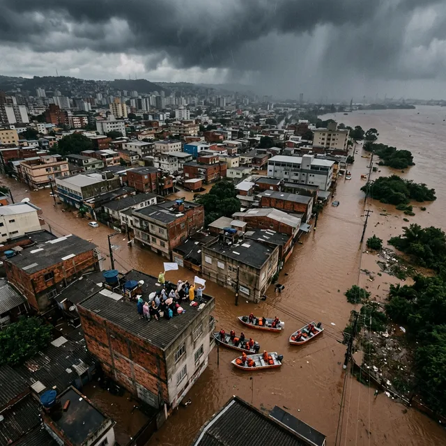
For the second consecutive year, the state of Minas Gerais in southeastern Brazil confronts an extraordinary rainy season characterized by relentless downpours, devastating riverine floods, and fatal hillside landslides. Between January and early March 2026, cumulative precipitation totals across multiple hydrographic basins surpassed historical meteorological records, submerging entire urban centers under meters of muddy river water in mere hours. The natural disaster triggered official states of emergency across more than one hundred forty-seven municipalities, displacing over thirty-eight thousand residents and paralyzing regional economic supply chains.
The operational reality on the ground remains severe: concrete bridges washed away by surging river currents, federal highways severed by collapsed embankments, electrical grids knocked offline, and public hospitals flooded up to second-floor inpatient wards. Tens of thousands of displaced citizens remain isolated in makeshift community centers and municipal schools without stable access to potable tap water, electricity, or basic hygiene provisions. Behind the immediate emergency lies an inescapable structural reality: the intersection of extreme meteorological volatility driven by global climate change and decades of unregulated hillside urbanization.
State and federal civil defense authorities mobilized thousands of emergency responders, military personnel, and volunteer rescue brigades. However, local community leaders and engineering experts emphasize that emergency humanitarian deployments cannot substitute for permanent geotechnical interventions, long-term urban zoning reforms, and systematic relocation of vulnerable populations inhabiting precarious geological slopes.
The Scope of the Crisis: Verified Casualties and Economic Impact
The physical dimensions of the 2026 flood season illustrate the catastrophic toll inflicted upon southeastern Brazilian communities.
The overview of verified indicators between January and March 2026 outlines the scale of physical destruction:
- Municipalities Under Declared Emergency: 147+ local government jurisdictions.
- Municipalities Under Full Disaster Calamity Decrees: 12 commercial and industrial hubs.
- Displaced and Homeless Individuals: Over 38,000 citizens registered in emergency shelters.
- Confirmed Fatalities: 23 individuals, primarily victims of sudden structural mudslides.
- Unaccounted / Missing Persons: 7 individuals under active search by specialized canine units.
- Precipitation Anomalies: Regional rainfall exceeding 380% of historical 30-year climatological averages.
- Estimated Direct Infrastructure Losses: Exceeding R$ 2.8 billion (60 million USD).
Municipal Breakdown: Regional Epicenters and Infrastructure Damage
The disaster has impacted communities across distinct regional geographies, from industrial manufacturing clusters along the Vale do Aço to agricultural farming towns in the Zona da Mata.
The comparative table below outlines the geographical context, documented casualties, and infrastructure status across the most severely affected municipalities:
| Impacted Municipality / Region | River Basin & Geological Profile | Displaced Residents & Casualties | Critical Infrastructure & Property Damage | Civil Defense Operational Status |
|---|---|---|---|---|
| Governador Valadares | Rio Doce Basin (Narrow alluvial valley) | 9,400 displaced; 2 confirmed fatalities | Commercial center submerged; river peaked at 5.85m | Public Calamity declared; federal troops deployed |
| Ipatinga (Vale do Aço) | Piracicaba River (Steep lateritic slopes) | 4,200 displaced; 7 confirmed fatalities | Landslides destroyed 14 residential neighborhoods | State of Emergency; slope evacuation enforcement |
| Manhuaçu | Manhuaçu River (Rugged highland valley) | 2,800 displaced; 3 confirmed fatalities | Main vehicular bridge collapsed; city isolated for 48h | Emergency supply airlift corridors established |
| Caratinga | Doce River tributary (Saturated clay hills) | 3,100 displaced; 5 confirmed fatalities | 6 residential buildings completely buried by mudslides | Full emergency evacuation of hillside favelas |
| Zona da Mata Region | Paraíba do Sul Basin (Agricultural lowlands) | 6,500 displaced; 4 confirmed fatalities | Coffee plantations inundated; milk transport halted | Agricultural disaster relief mobilized |
| Northern Fluvial Communes | São Francisco Basin (Riverine floodplains) | 12,000 displaced; 2 confirmed fatalities | Complete loss of rural access roads & clean wells | Water purification river barges deployed |
In Governador Valadares, the Rio Doce crested nearly six meters above its normal channel depth, turning commercial avenues into turbulent waterways navigable only by flat-bottom aluminum military rescue boats. In the industrial region of Vale do Aço, severe flooding halted heavy metallurgical production facilities, resulting in estimated direct industrial losses exceeding five hundred million reais within a single two-week period.
Geological and Human Factors Driving Extreme Vulnerability
The recurrence of catastrophic flooding in Minas Gerais is rooted in a volatile combination of physical geography, regional geology, and unplanned urban sprawl.
Geomorphological and Hydrological Factors
- Rugged Highland Topography: Mountain formations such as the Serra da Mantiqueira and Serra do Espinhaço form narrow, deeply incised valleys. Rain falling over vast catchment areas concentrates rapidly into riverbeds with limited flood basins, causing surface waters to surge violently toward populated valley floors.
- Extensive Interconnected River Networks: The state encompasses the headwaters of four major South American drainage basins: the Rio Doce, Rio São Francisco, Rio Jequitinhonha, and Rio Grande. Peak seasonal rains upstream converge into inhabited floodplains with high velocity.
- Unstable Lateritic Soils: The typical regional red clay soils are rich in iron and aluminum oxides. Under prolonged soaking, these lateritic soils become fluid, dramatically increasing soil weight while losing internal shear strength, producing rapid slope collapses.
- Historical Atlantic Forest Deforestation: Centuries of agricultural clearing and mineral extraction reduced the native Atlantic Forest canopy to approximately eleven percent of its original cover. Without deep forest root networks to intercept rainfall, surface water runoff accelerates directly into stream channels.
Socioeconomic and Urban Planning Deficits
- Informal Hillside Urbanization: Economic inequality forces low-income families to construct masonry houses on steep, geotechnically unstable slopes classified as extreme-risk zones by the Geological Survey of Brazil (CPRM).
- Outdated Drainage Architecture: Stormwater drainage networks in major municipalities were engineered based on mid-twentieth-century hydrological standards, proving incapable of handling contemporary high-volume storm bursts.
- Soil Impermeabilization: Uncontrolled paving and asphalt surfacing prevent natural stormwater infiltration, converting suburban avenues into artificial torrents that overwhelm natural stream channels.
- River Siltation: Decades of unmanaged sediment runoff and illegal debris dumping have filled riverbeds, substantially reducing the physical volume of water rivers can accommodate before overflowing.
The Connection with Anthropogenic Climate Change
Meteorologists and climate scientists emphasize that the extreme weather battering southeastern Brazil is directly connected to broader global climatic destabilization. Assessments by the Intergovernmental Panel on Climate Change (IPCC) and Brazil’s National Institute for Space Research (INPE) indicate that tropical South America is experiencing significant shifts in hydrological patterns.
Key climatological drivers include:
- Thermal Expansion in the South Atlantic: Ocean surface temperatures across the tropical South Atlantic have increased by an average of 1.2°C since 1980. Warmer ocean waters generate elevated rates of atmospheric evaporation, producing dense atmospheric moisture corridors (the South Atlantic Convergence Zone, or SACZ) that stall over southeastern Brazil for days.
- Concentration of Precipitation Events: Rather than distributing evenly across a multi-month monsoon cycle, annual rainfall increasingly falls in concentrated, violent storms. The frequency of extreme downpours in southeastern Brazil has climbed thirty-seven percent since 2000.
- Prolonged Atmospheric Blocking: Atmospheric high-pressure systems frequently trap moisture bands over the mountains of Minas Gerais, causing multi-day downpours where rainfall totals surpass monthly averages in under forty-eight hours.
Hillside Landslides: The Deadliest Consequence of the Storms
While riverine inundation causes massive physical and commercial destruction, hillside landslides account for the overwhelming majority of fatalities during tropical rainy seasons. In Minas Gerais, the fatal landslide sequence follows a predictable geotechnical pattern:
- Heavy rain falls continuously over five to seven consecutive days, fully saturating the porous upper soil layer.
- The underground water table rises to the surface, creating high pore-water pressure that liquefies the soil interface.
- Precariously terraced slopes fail catastrophically, sending thousands of tons of mud, boulders, and uprooted trees down mountainsides.
- Multi-story homes are crushed in seconds, frequently during early morning hours while sleeping families are unable to evacuate.
In Ipatinga’s Bethânia neighborhood, a saturated hillside collapsed at three o'clock in the morning, burying three residential homes and claiming four lives instantly. In Caratinga, six houses were leveled along a steep street, underscoring the lethal hazard facing families who have no financial alternative to building on geologically unstable hillsides.
Emergency Government Mobilization and Structural Criticisms
The coordinated humanitarian response brought together multiple federal and state agencies:
- Armed Forces Deployment: More than 3,500 personnel from the Brazilian Army and Navy deployed with tactical amphibious transports, utility helicopters, and specialized watercraft.
- State Civil Defense Operations: Disaster response units across all 853 municipalities mobilized with search-and-rescue teams and structural engineers.
- Federal Emergency Financing: Release of R$ 1.2 billion in emergency reconstruction tranches to restore roads, clear debris, and rebuild bridges.
- Temporary Shelter Management: Conversion of 340 public schools, gymnasiums, and municipal pavilions into managed shelters providing meals and medical care.
- Potable Water Distribution: Deployment of mobile water purification trucks and drinking water supply fleets to forty-seven municipalities where local water treatment plants were submerged.
Despite these immediate efforts, civil society leaders, urban geologists, and public prosecutors continue to criticize persistent governance failures. State budgets consistently allocate fifteen times more capital to post-disaster cleanup and emergency payouts than to proactive geotechnical mitigation, slope terracing, and municipal drainage upgrades. Early warning SMS alerts frequently reach vulnerable residents after hillsides have already begun to move, while long-delayed social housing projects leave thousands of registered families living on condemned slopes indefinitely.
Humanitarian Aid Channels and Responsible Public Support
Individuals and organizations seeking to support relief efforts for displaced families across Minas Gerais can contribute through verified institutional conduits:
- State Civil Defense of Minas Gerais: Official emergency disaster relief campaigns managed by regional authorities.
- Brazilian Red Cross (Cruz Vermelha Brasileira): Deployment of specialized field medical kits, personal hygiene supplies, and trauma care.
- Cáritas Brasileira: Faith-based community aid organizing clean clothing, bedding, and infant nutrition in rural communities.
Relief coordinators emphasize that high-priority donations include sealed bottled water, chlorine disinfectant, hygiene supplies, non-perishable canned food, and new undergarments. Donors are advised against sending unsorted bulk used clothing or perishable items, which frequently overwhelm logistical collection centers.
Meteorological Outlook and the Imperative for Climate Adaptation
Meteorological models from the National Institute of Meteorology (INMET) indicate that high-risk hydrological conditions will persist through late March 2026. While rainfall intensity may taper gradually, saturated soils will maintain elevated landslide risks for weeks after skies clear.
Minas Gerais faces an urgent reckoning with its environmental and urban policies. Rebuilding flooded communities in identical alluvial zones without expanding drainage infrastructure guarantees recurring destruction during future rainy seasons. Protecting human lives requires substantial investments in geotechnical slope stabilization, the restoration of degraded Atlantic Forest watersheds, and the relocation of vulnerable communities to secure, climate-resilient neighborhoods.
Institutional Sources and Official References
- Defesa Civil do Estado de Minas Gerais — Official Emergency Bulletins and Disaster Telemetry
- Instituto Nacional de Meteorologia (INMET) — Climatological Precipitation Forecasts
- Instituto Nacional de Pesquisas Espaciais (INPE) — Earth System Science and Hydrological Monitoring
- Geological Survey of Brazil (CPRM) — Hillside Risk Cartography and Geotechnical Reports
- Intergovernmental Panel on Climate Change (IPCC) — Sixth Assessment Report: Climate Impacts in South America