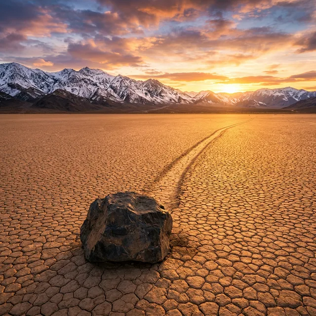
In the arid basin of Death Valley National Park in California lies Racetrack Playa, a dry lakebed where heavy dolomite and syenite boulders weighing up to 300 kilograms travel across the desert floor, carving distinct linear furrows that stretch across hundreds of meters. For nearly a century, these self-propelling "sailing stones" puzzled earth scientists, park rangers, and visitors. Because no human observer had ever witnessed the physical displacement in real time, the phenomenon invited speculations ranging from gravitational anomalies and localized seismic tremors to hurricane-force desert squalls. In late 2013 and early 2014, an exhaustive observational study led by paleobiologists Richard Norris and James Norris demystified the process, proving that the boulders are pushed across water-lubricated mud by thin sheets of wind-driven floating ice.
The resolution of the Racetrack Playa mystery stands as an exemplary demonstration of patience and empirical field instrumentation in geomorphology. By installing automated GPS tracking modules, time-lapse cameras, and high-precision meteorological logging stations, researchers documented that stone mobility requires a rare combination of desert rain, nocturnal sub-zero freezing, morning solar fracturing, and steady wind currents. This delicate environmental interaction operates only under specific conditions, illustrating how subtle mechanical interactions shape geological landscapes.
Beyond solving a longstanding desert puzzle, understanding Racetrack Playa's physical dynamics provides valuable insights for comparative planetary geology. Analogous flat sediment depressions on Mars, known as desiccated lacustrine playas, exhibit puzzling linear surface grooves that may have formed under comparable cryogenic ice-rafting conditions during wetter Martian epochs. The sliding rocks of California offer an ideal terrestrial proving ground to interpret surface dynamics on other worlds.
Geographic Setting: The Topography of Racetrack Playa
Racetrack Playa occupies an endorheic mountain valley at an elevation of 1,131 meters above sea level between the Cottonwood and Nelson mountain ranges. Approximately 4.5 kilometers long by 2 kilometers wide, the dry lake bed features an exceptionally level surface of cracked clay, varying by only a few centimeters in relief across its entire extent.
The lakebed sediments consist of fine-grained montmorillonite clay and silt washed down from surrounding dolomitic highlands. When dry, this fine sediment shrinks into polygonal mud cracks. When moistened by winter precipitation—which averages less than 50 millimeters annually—the clay minerals absorb water and transform into a slick, frictionless slurry with an exceptionally low shear resistance.
The following table summarizes the primary physical and meteorological dimensions governing Racetrack Playa and its sailing stones:
| Physical / Geological Parameter | Quantitative Measured Value | Environmental Context | Field Measurement Method |
|---|---|---|---|
| Tracked Boulders in Playa | Over 162 mapped stones | Dolomite and intrusive syenite | High-resolution aerial LiDAR & field survey |
| Maximum Recorded Rock Weight | Derived from south cliff face | Portable mechanical load scales | |
| Longest Continuous Trail | 457 meters (1,500 feet) | Shallow mud furrow with raised ridges | High-precision differential GPS mapping |
| Measured Movement Velocity | 2 to 6 meters per minute | Steady, non-accelerating creep | Embedded internal GPS accelerometer loggers |
| Ice Thickness During Motion | 3 to 5 millimeters | Ultra-thin floating surface panels | Direct field calipers and macro cameras |
These parameters establish that the movement is not catastrophic or violent, but a smooth glide across mud lubricated by thin water films.
A Century of Speculation: The Historical Hypotheses
The sailing stones were first documented in 1915 by prospector Joseph Crook, who noticed long, meandering furrows in the dried mud ending at individual rock boulders. In 1948, geologists Jim McAllister and Allen Agnew published the earliest formal scientific survey of Racetrack Playa, mapping dozens of rock positions and directional trails.
Over the ensuing decades, researchers proposed numerous hypotheses to explain how massive boulders moved across flat ground without human or animal tracks:
- Hurricane-Force Wind Gusts: Early researchers postulated that rare winter storms generated extreme wind gusts across the valley. However, physics calculations indicated that moving a 300-kilogram angular dolomite rock over saturated mud would require sustained surface winds exceeding 800 kilometers per hour—speeds physically impossible in the valley.
- Seismic Tremors and Gravity Creep: Others suggested that frequent low-magnitude earthquakes along nearby California fault lines caused the boulders to slide. Yet seismic shaking would move all rocks simultaneously in identical directions, whereas real-world tracks frequently show divergent vectors and perpendicular turns.
- Subterranean Magnetism: Speculation that regional magnetic anomalies pulled iron-rich boulders across the mud was quickly disproven when mineralogical assays confirmed the rocks are composed of non-magnetic calcium-magnesium dolomite.
The primary obstacle to resolving the debate was that nobody had ever observed the rocks moving. Researchers regularly discovered fresh furrows following winter storms, but the actual displacement occurred unobserved.
The Definitive Experiment: The Slippery Rock Project
In 2011, paleobiologists Richard Norris of the Scripps Institution of Oceanography and his cousin James Norris launched the "Slippery Rock Project." Recognizing that continuous physical monitoring was essential, the researchers installed fifteen calibrated replica stones fitted with custom waterproof GPS units and orientation accelerometers.
The team also established a solar-powered meteorological station on the playa rim to record wind speed, air temperature, relative humidity, and solar radiation at one-minute intervals. Time-lapse cameras were positioned around the perimeter to document weather patterns across the basin.
For two years, the experimental equipment recorded only calm desert heat and dry dust storms. The instrumented stones remained completely stationary, testing the researchers' patience.
The Discovery of December 2013: Ice, Water, and Wind Convergence
In late November 2013, an unusual winter storm system deposited snow and rain across Death Valley, submerging the southern half of Racetrack Playa beneath seven centimeters of standing water. In December 2013, Richard and James Norris arrived at the site to inspect the flooded basin.
During sub-freezing desert nights, temperatures plunged to minus three degrees Celsius, causing the shallow water to freeze into an expansive, paper-thin ice sheet between three and five millimeters thick. On the morning of December 20, the winter sun began warming the playa, causing the brittle ice sheet to fracture into broad floating floes driven by gentle morning breezes blowing at twelve to sixteen kilometers per hour.
As the floating ice sheets moved across the shallow pond, their leading edges made contact with the boulders protruding above the water. Acting as vast natural sails, the ice floes transferred the gentle momentum of the wind directly to the rocks. Resting on saturated clay that acted like a slick lubricant, the heavy stones began sliding across the mud at speeds between two and six meters per minute, carving distinct furrows in the sediment below.
The researchers witnessed and photographed dozens of stones moving simultaneously across the playa, documenting the solution to a mystery that had resisted explanation for nearly a century.
Multi-Factor Hydrodynamic Mechanism of Rock Movement
The empirical evidence established that the sailing stones require five specific environmental conditions to align:
- Shallow Basin Inundation: Winter precipitation must cover the playa with five to seven centimeters of water—enough to allow ice to float freely without completely submerging the boulders.
- Sub-Zero Nocturnal Freezing: Air temperatures must fall below freezing to form floating ice sheets between three and five millimeters thick. Thicker ice freezes the rocks in place, preventing movement.
- Morning Solar Fracturing: Sunlight must warm the surface to fracture the continuous ice sheet into large, floating panels resembling miniature tectonic plates.
- Moderate Wind Currents: Gentle breezes between ten and eighteen kilometers per hour must blow across the basin to drive the floating ice floes across the water.
- Low-Friction Mud Lubricant: Saturated montmorillonite clay under the stones provides an almost frictionless surface, enabling modest wind forces to propel multi-hundred-kilogram boulders.
When any of these five factors is missing, the rocks remain stationary. This environmental sensitivity explains why movement events occur only a handful of times per decade and typically last only a few hours.
Trail Geometries and Decoupled Rock Vectors
The floating-ice mechanism resolves another puzzling aspect of the sailing stones: their complex trail patterns. Observers had long noted that adjacent stones often produced trails that curved sharply, ran parallel for dozens of meters, and then abruptly diverged.
The Norris study demonstrated that trail geometries are governed by the motion of individual floating ice floes. When a large ice sheet pushes several stones simultaneously, their trails remain strictly parallel. When local thermal currents or shifting wind gusts cause the ice floe to rotate or fracture into smaller pieces, the propelled rocks diverge along independent trajectories, creating zigzags and loops.
Once the pond waters evaporate in late spring, the sun bakes the wet furrows into hard, durable impressions in the mud. Protected by the desert's extreme aridity, these tracks remain visible for years until the next major flooding event levels the sediment once again.
Official Geological References and Technical Documentation
- PLOS ONE — Norris et al. (2014): Sliding Rocks on Racetrack Playa, Death Valley National Park: First Observation of Rocks in Motion.
- United States Geological Survey (USGS) — Geomorphology, Hydrology, and Sedimentology of Desert Playas in the Great Basin.
- National Park Service (NPS) — Death Valley National Park Geology: The Mystery of the Sailing Stones.
- Nature — Physical mechanics of wind-driven thin-ice transport in arid lacustrine environments.