
🌍 Your knowledge portal
MYSTERIES

Peabiru Path: The Ancestral Route Linking Brazil to the Incas

📅 2026-07-24🔄 Updated: 2026-10-12⏱️ 7 min read📝
⚡

Quick Summary

Discover the Peabiru Path, the mysterious 4,000 km transcontinental network that cut through São Paulo, Paraná, and Mato Grosso do Sul to the Peruvian Andes. Centuries before European caravels anchored along the South American coastline, an extensive network of paved and compacted indigenous trails cut across the heart of the continent.

Key Takeaways:

  • With an estimated expanse exceeding four thousand kilometers, the Peabiru Path was never a crude, accidental footpath through the jungle.
  • One of the most geographically crucial and strategically vital segments of the Peabiru crossed the state of Mato Grosso do Sul.
  • The municipality of Aquidauana, positioned in western Mato Grosso do Sul, held a decisive role in the architectural continuity of the Peabiru network.
Peabiru Path: The Ancestral Route Linking Brazil to the Incas
Peabiru Path: The Ancestral Route Linking Brazil to the Incas — High-Fidelity Artistic Illustration created by artificial intelligence based on scientific research.

Centuries before European caravels anchored along the South American coastline, an extensive network of paved and compacted indigenous trails cut across the heart of the continent. The Peabiru Path linked the sunlit shores of the Atlantic Ocean in southern and southeastern Brazil directly to the majestic Andean cordilleras in Cusco, Peru, continuing all the way to the Pacific coastline. This monumental highway network spanned over four thousand kilometers, cutting through rugged mountain ridges, dense subtropical rainforests, river canyons, and the vast wetland expanses of the Pantanal.

Today, the original course of this pre-Columbian highway is the subject of rigorous archaeological debate and scientific field research across South America. Anthropologists and geophysicists from the National Institute of Historic and Artistic Heritage (IPHAN), federal universities, and municipal research teams are deploying modern remote sensing to authenticate its ancient roadbeds. Determining the authentic routes of the Peabiru is not merely an academic endeavor; it restores historical recognition to sophisticated pre-colonial indigenous civilizations and establishes heritage corridors for regional conservation.

The term Peabiru finds its etymological roots in the Tupi-Guarani linguistic family, where pe designates a path, while abiru or aviru signifies beaten earth, crushed grass, or a sacred skyward journey. Indigenous oral traditions describe the road as an earthly reflection of the Milky Way, a terrestrial pilgrimage route known as the search for the Yvy Marãne'ỹ, the ancestral "Land Without Evil." Beyond its profound cosmological and ritual meaning, the Peabiru functioned as a primary conduit for inter-tribal commerce, genetic exchange, diplomatic treaties, and widespread seasonal migrations.
Transcontinental Engineering Across South America #

With an estimated expanse exceeding four thousand kilometers, the Peabiru Path was never a crude, accidental footpath through the jungle. It was a deliberately engineered transit system measuring approximately 1.40 meters in width, uniformly excavated between thirty and fifty centimeters beneath natural ground levels. This sunken construction served multiple hydrological functions: it channeled surface runoff away during torrential rains, shielded walking travelers from cutting winds, and created clear boundary markers across varied biomes.

In vulnerable sectors characterized by heavy vegetation or soils susceptible to intense tropical erosion, indigenous engineers lined the trail bed with a specialized rhizomatous turf (Paspalum notatum), commonly called horse-grass. This robust botanical carpeting inhibited the growth of deep-rooted trees, prevented overgrowth, and preserved an open walking bed for centuries without requiring manual maintenance. Where the road traversed boggy marshes and floodplains, workers built raised causeways reinforced with river boulders and gravel backfill.

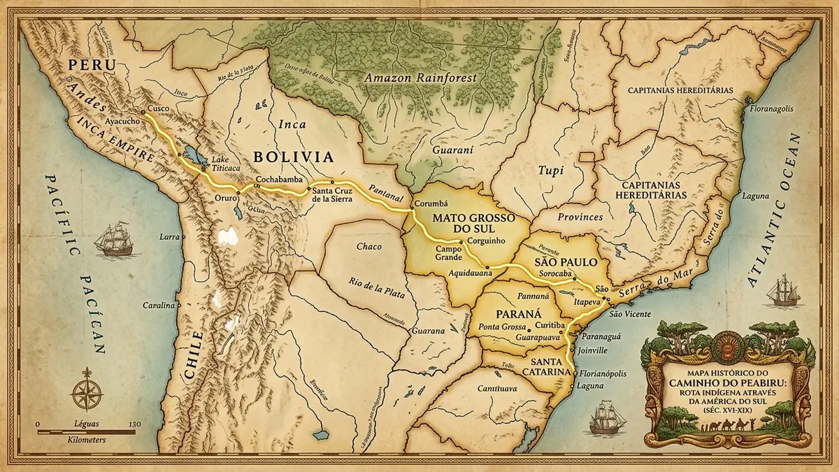
The trunk routes departed from multiple coastal embarkation zones, including Paranaguá Bay in Paraná, Cananéia and São Vicente in São Paulo, and Santa Catarina Island. Converging inland along the river valleys of the Iguaçu, Tibagi, and Paranapanema, the highway intersected strategic plateaus across southern Brazil before branching across the modern territory of Mato Grosso do Sul. From there, the arterial corridors traversed modern-day Paraguay and Bolivia, scaling the eastern Andean slopes toward the imperial capital of the Inca Empire in Cusco.

Historical Map of the Peabiru Path across Mato Grosso do Sul, Paraná, and São Paulo

The Mato Grosso do Sul Route: The Pantanal Axis and Guaycuru Corridor #

One of the most geographically crucial and strategically vital segments of the Peabiru crossed the state of Mato Grosso do Sul. Historically navigated by Guarani, Paresi, and Terena communities, as well as the formidable equestrian warriors of the Guaycuru confederacies, this branch represented the primary transcontinental corridor connecting the Paraná River basin with the upper Pantanal and the Bolivian Chaco.

Archaeological expeditions have identified distinct topological checkpoints along this western axis:

  • Paraná River Crossings (Bataguassu and Três Lagoas): The primary continental gateway for travelers heading west from the São Paulo coastline and northern Paraná, utilizing natural shallow shoals and riverine sandbars.
  • The Maracaju Plateau and Campo Grande: Traversal along the elevated crest of the Maracaju Range through Dourados, Sidrolândia, Campo Grande, and Corguinho, where sandstone caves containing geometric petroglyphs served as seasonal camps and celestial observation points.
  • The Historic Aquidauana Bottleneck: A mandatory geographic passage through the Piraputanga Range and Paxixi Valley, facilitating the descent from high plateaus down into the Pantanal floodplains.
  • The Corumbá Gateway to the Andes: Reaching the limestone bluffs of Corumbá and the border regions of Puerto Suárez and Chiquitos, where the trail plunged into the Gran Chaco toward Potosí and Chuquisaca.

Archaeological Investigations in Aquidauana: The Piraputanga Chokepoint #

The municipality of Aquidauana, positioned in western Mato Grosso do Sul, held a decisive role in the architectural continuity of the Peabiru network. Situated precisely at the geologic transition between the Maracaju sandstone plateaus and the vast sedimentary lowlands of the Pantanal, Aquidauana constituted a natural bottleneck where travelers had to navigate rugged escarpments to reach safe river crossings.

Extensive archaeological digs and ethnohistorical surveys have mapped four focal areas within the Aquidauana corridor:

  • The Piraputanga and Camisão Gorges: The trail branched southward from Corguinho, entering the municipality through the natural gaps of Piraputanga and Camisão.Towering sandstone cliffs provided thermal shelter from torrential squalls, reliable spring water, and defensive vantage points overlooking the valley.
  • The Paxixi Valley and Sandstone Lookouts: Travelers skirted the flanks of Morro do Paxixi, following linear rock art panels that served as topographic waypoints leading toward subterranean aquifers.
  • The Natural Ford of the Aquidauana River: Crossings occurred at shallow rapids near the historic town center and the Ponte de Pedra sector, where researchers have cataloged polished stone axes, ceramic sherds, and lithic flakes.
  • The Miranda and Pantanal Connection: Beyond the river crossing, the road continued toward Anastácio and Miranda through traditional Guaná territories, tracing elevated sand ridges known as cordilheiras to stay above annual seasonal floodwaters.

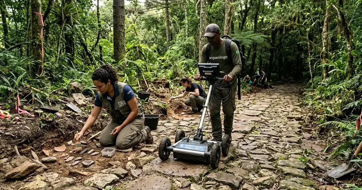
Archaeologists using Ground Penetrating Radar to map the Peabiru Path

Archaeological Methodologies and Technological Impact #

Authenticating the physical course of the Peabiru through non-destructive geophysical techniques has revolutionized modern South American archaeology. Ground-penetrating radar and aerial laser surveys allow researchers to detect sub-surface features beneath dense vegetation without disturbing fragile ecological reserves or sacred indigenous burial sites.

The comparative table below outlines the primary technological methodologies utilized in the contemporary rediscovery and mapping of the Peabiru Path:

Mapping Technology Archaeological Application Technical Conclusion Scientific Relevance
Ground Penetrating Radar (GPR) Detection of sub-surface pavement layers beneath sandy topsoil Uncovers buried stone roadbeds and compacted clay foundations Direct physical validation of pre-Columbian highway infrastructure
Airborne LiDAR Scanning High-density laser pulses penetrating thick forest canopy Reveals ditch contours, drainage cuts, and sunken path edges Discovery of forgotten feeder trails hidden within Atlantic Rainforest
Radiocarbon Dating (AMS) Isotope analysis of organic charcoal from trailside hearths Establishes chronological sequence of human occupation layers Conclusive evidence of active commercial transit dating back 2,000 years
Ethnobotanical Surveying Mapping localized colonies of exotic Paspalum notatum Correlates continuous linear distributions of non-native turf Biological tracking of ancient footpaths across diverse ecosystems

Geophysical surveys have revealed that the Peabiru was frequently flanked by perimeter drainage swales designed to prevent mud deposition during seasonal monsoons. Such sophisticated water diversion structures confirm that pre-Columbian engineers understood soil mechanics and hydrology on an extraordinary scale.

Historical Chronicles of the Inca Connection and Aleixo Garcia #

Physical evidence of transcontinental communication between Brazil's Atlantic coast and the Andean heartland is documented in early sixteenth-century colonial chronicles. In 1524, roughly eight years before Francisco Pizarro reached Cajamarca, the Portuguese castaway Aleixo Garcia led an expedition from Santa Catarina along the Peabiru. Guided by an alliance of over two thousand Guarani warriors, Garcia traversed Paraná, crossed the Paraná and Paraguay rivers, and marched across the Chaco into the Andean foothills.

Garcia reached the eastern perimeter of the Inca Empire in modern-day Bolivia near Sucre and Tomina, plundering silver textiles and metallurgical artifacts from Incan outposts before retreating eastward. While Garcia was killed on his return near the Paraguay River, specimens of Incan silver and metalwork reached the Atlantic coast, giving rise to European legends of the "White King" and the "Silver Mountains" (Sierra de la Plata). These reports ultimately motivated Martim Afonso de Sousa's 1531 expedition to São Vicente and inspired Spanish colonizers to establish Buenos Aires and Asunción.

Subsequent Jesuit accounts from the sixteenth and seventeenth centuries frequently mention the Peabiru as an established trade highway maintained by regular indigenous foot traffic. Modern conservation efforts seek to preserve remaining segments from expanding agricultural monocultures and road paving, securing this ancestral heritage for future generations.


Scientific References and Historical Sources #

🏷️ Tags:

#PeabiruPath#BrazilArchaeology#AncestralIndigenousTrail#AquidauanaPeabiru#MatoGrossodoSulPeabiru#PiraputangaRange#Pre-ColumbianHistory

📢 Gostou deste artigo?

Compartilhe com seus amigos e nos conte o que você achou nos comentários!

Receba novidades!

Cadastre seu email e receba as melhores curiosidades toda semana.

🔒 Sem spam. Cancele quando quiser.

💬 Comentários (0)

Seja o primeiro a comentar! 👋

Receba novidades no WhatsApp!